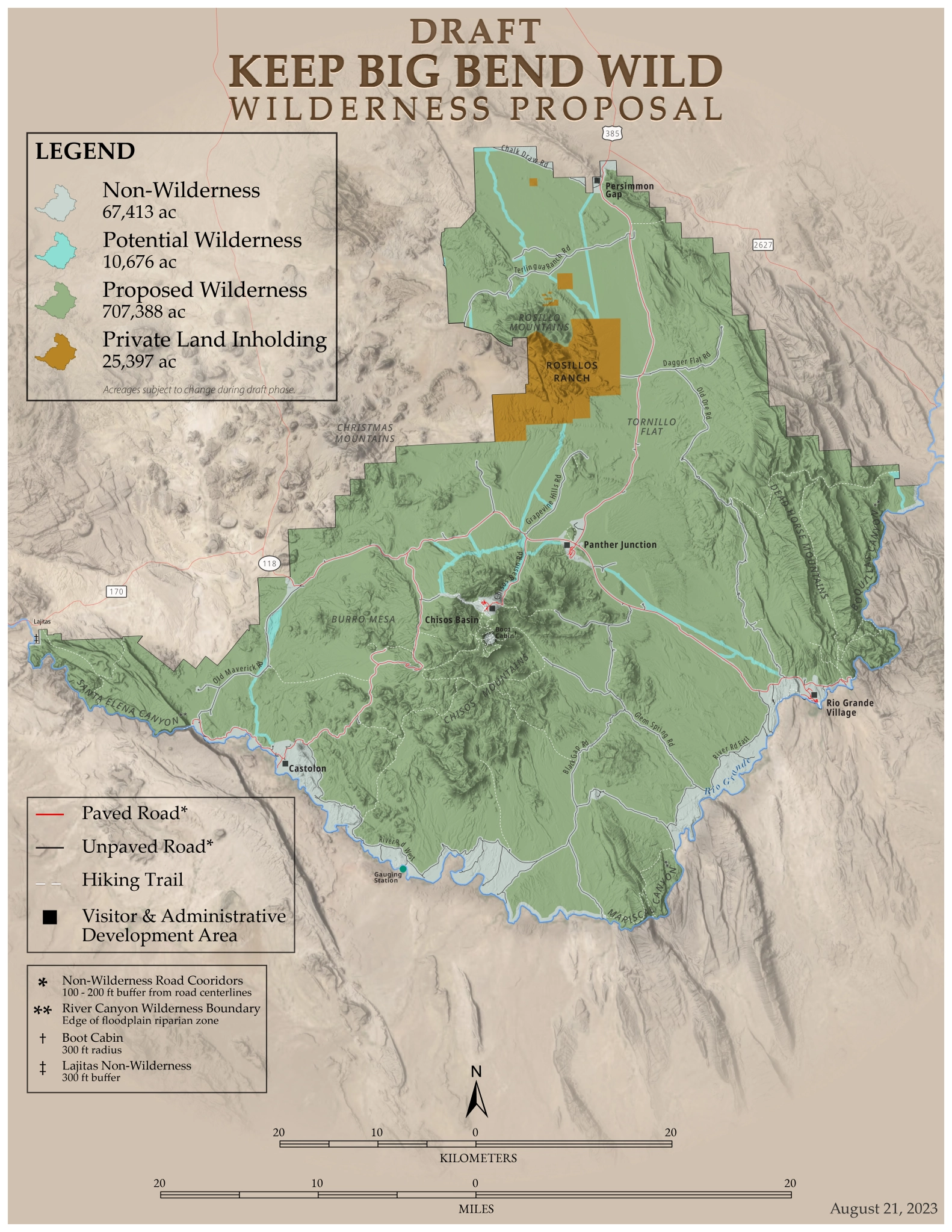
Draft Wilderness Map
In 1978 the National Park Service completed a multi-year Big Bend wilderness study which resulted in a recommendation to Congress that 538,250 acres of the park be designated as wilderness and 44,750 acres be identified as potential wilderness. Together, this added up to about 4/5 of the park’s acreage. In 2023, the NPS determined that an additional 63,505 acres that were added to the park after 1978 met the criteria for wilderness designation by Congress. While the NPS is currently managing all of these lands to protect their wilderness character, that policy can change in the future. Only Congress can make those protections permanent.
Mapping technology has changed greatly, and more than 45 years of experience since 1978 suggest that those boundaries can be improved upon without impacting current visitor or administrative uses in any way. Keep Big Bend Wild has worked with the NPS while developing its own boundary proposal for wilderness, published here; this has been shared at KBBW’s public meetings as well.
KBBW’s draft wilderness boundary map builds upon the areas recommended by the NPS in 1978 for wilderness designation and currently managed by the NPS to protect wilderness values (approximately 81% of the park’s current acreage), with some minor , but important, improvements, briefly summarized here:
- More wilderness in the North Rosillos (noted above).
- Narrowing pre-GPS road corridors to the widths necessary to maintain existing drainage and engineering structures along both paved and unpaved roads. 100 feet on either side of the centerline will work in most places, but in some areas it may be necessary to have them extend as much as 300 feet. Where terrain allows, the narrower corridors would still allow for some expanded parking adjacent to wilderness trailheads, if needed in the future. Identification of specific non-wilderness road corridor widths throughout the park for the KBBW map is a work-in-progress. The reduced non-wilderness road corridor widths from the 1978 map would have no impact on any existing development or uses.
- Black Gap Road, recommended by NPS for wilderness designation in 1978, is not included in the KBBW proposal. Driving this road remains a vital part of many Big Bend visitors’ experience and KBBW sees no benefit to closing it.
- Boot Cabin, in the High Chisos, remains an important administrative facility for NPS trail crews working in the mountains. KBBW proposes that the cabin, corral, and two small outbuildings that surround it, be excluded from designated wilderness in order to allow continued use and maintenance of these facilities by the park trail crew and other staff conducting multi-day resource management trips to manage the surrounding wilderness area.
KBBW’s proposal would protect approximately 90% of the current park acreage as designated wilderness, with the bulk of the difference from the NPS 1978 recommendation coming from the addition of the North Rosillos as well as the narrowing of the overly-wide road corridors.
Note that no private lands are included in the KBBW proposal, and all lands proposed for wilderness designation are already owned and managed by the NPS. All existing public roads and developments and the Rio Grande are excluded from the proposed wilderness as well. The “Potential Wilderness” on the map reflects existing utility line corridors, which both KBBW and the NPS hope will be obsolete or can be relocated in the future without impacting park operations and visitor services.
It’s also important to note that KBBW is proposing the same boundaries in the Chisos Basin area as the NPS recommended in 1978. With the exception of Boot Cabin noted above, the vast majority of the High Chisos, including vital habitat for black bears, greater long-nosed bats and many other rare or endemic species, would be in designated wilderness. Many non-wilderness areas in the immediate vicinity of the existing Basin development are too steep for any additional infrastructure. The planned rehab of the Lodge and potable water infrastructure that will occur in the Basin, as well as all other Basin facilities, are outside of wilderness and would not be impacted by wilderness designation. Limited water availability and the configuration of the roads and parking areas in this mountainous terrain make the likelihood of any additional facility growth unlikely, regardless of wilderness boundaries.
Ultimately, wilderness designation requires Congressional action, so KBBW’s map also aims at maximizing public support. This map is a work-in-progress and KBBW welcomes your input to improve the proposal to protect the park’s wild, undeveloped character where it still exists.
Support Keep Big Bend Wild
Click this button to add your name to the growing list of individuals, businesses, and organizations supporting a wilderness designation for the undeveloped lands of Big Bend National Park.
If you would also be willing to help support Keep Big Bend Wild financially please click Donate.
Every contribution helps defray the cost of our volunteers to produce materials and travel to meetings to build awareness and strengthen our coalition.
Contributions supporting Keep Big Bend Wild are managed by the El Paso Community Foundation and are tax deductible as allowed by law.
© 2026 Keep Big Bend Wild.
Layout by Jess Repanshek and Kubio.
Images © Rebecca Latson.
Keep Big Bend Wild
P.O. Box 66
Big Bend National Park, TX, 79834